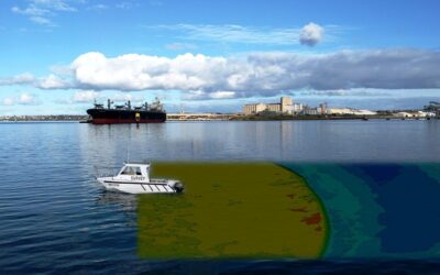
Measurement, description, and prediction of changes in oceans, seas, coastal areas, lakes, and rivers are the primary goal of hydrography. However, this branch of applied sciences also deals with other marine activities such as economic development, security, defense, scientific research, and environmental protection. Let’s know how Hydrographic Analysis is important…
Hydrographic Data Expansion Past Charting –
Once you acquire hydrographic data, you may repeatedly put it to good use. Advances in data processing technology provide a deeper awareness of our surroundings, which creates new opportunities and directly supports the so-called “blue economics.”.” This is an important fact that policymakers frequently overlook due to a lack of familiarity with hydrography. It has been defined solely by one result for centuries: the chart. This graphic is only useful for the rest of the globe if something horrible happens.
Geospatial analysis, i.e., the usage of GIS, becomes critical when hydrographic data is employed in a broader context like oceanography, pollution control, offshore energy, or any other marine area of study. Aside from the value of sounding corrections’ and the information contained in charts, all of the information gathered during hydrographic surveys includes velocity and sediment profiles, ADCP casts, tide, current data, turbidity, and shoreline data, is extremely valuable. “gathering once and utilizing many times” takes on new meaning in geographic information systems (GIS).
Bathymetry is likely the most important contribution of hydrography in the maritime community, which feeds nautical charts and every maritime project. In addition, hydrographic data is essential for any operation on the sea or in coastal areas. As a result, a Marine GIS can rely on it as a primary data source. When it comes down to it, hydrographic data and geographic information systems are essential to the ocean and coastal economic activity growth.
Hydrographic Standards –
Other maritime sciences lack Hydrography’s established data collection, analysis, and production standards. This may be a significant distinction. It is now possible for Hydrographers to think GIS with the new IHO S-100 Universal Hydrographic Data Model, which is based on the ISO 19000 series and TC211 for international geo-standards. Not only can they produce charts, but they can also develop new Geographic Markup Language (GML) schemas to utilize hydrographic data in various ways, from traditional safety of navigation such as the S-101 next generation of ENCs to the new bathymetry raster standard S-102 or Ice Coverage Seabed Survey Data Model, a geographic model based on Esri Geodatabase model, may one day become an S-100 based GML in other industries, such as Oil & Gas. Hydrographic data can be used to provide geographical data, not just charts.
Final Words…!!!
The cornerstone of Marine SDIs can be considered hydrographic data. Its usage extends beyond ensuring the safety of navigation to assist Hydrographers and Nautical Cartographers in their development as GIS experts. Data after Hydrographic Analysis is used for and beyond chart production using cloud computing (public, private, or hybrid), big data analytics, and GIS applications.


