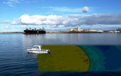
Our oceans’ health and our planet’s health are intertwined. But the relationship between what we know and how we preserve it isn’t always evident.
In this post, we will discuss five reasons why improved mapping might help us understand and maintain our ocean ecosystem and one reason why mapping could harm it. See the five main reasons for charting the ocean bottom via Marine Mapping.
● Barrier
Many essential maritime habitats are endangered by overexploitation, threatening human and animal populations. By 2030, 30 percent of the world’s seas will be preserved under the 30×30 programme. But there are tremendous obstacles. On similar notes, as offshore renewable energy grows essential, ocean access and rights become critical for conservation and commercial initiatives. Ocean territories and responsibilities must be delineated for both programs to operate. But, with the ever-changing shoreline, this is easier said than done. Sound survey data and tidal observations are required to determine precise, mutually accepted borders and competence in maritime law. No shoreline means no protection for the oceans.
● Endurance
Coastal inundation threatens millions of people globally. Storm and tidal waves may submerge nearby regions, inflicting significant infrastructure damage and injury to vulnerable people. By 2100, increasing sea levels might impact up to 4.6 percent of the world population. Knowledge of the bottom and the shoreline may assist officials in constructing models that forecast the effect of coastal flooding on low-lying communities. They can safeguard communities by detecting at-risk regions. Planting mangroves, for example, may minimize the impact of large waves. Describing the implications of coastal shape and composition on coastal resilience is becoming more critical in Small Island Developing States.
● Possibilities
We know very little about the ocean’s ability to sustain life. We know more about the moon’s surface than the ocean’s bottom. Since the 1970s, more and more ocean research has led to the discovery of hitherto untapped resources such as new medications and genetic resources. But, if our seas are rich in natural riches, how can we utilize them sustainably and adequately? Habitat mapping, seabed sample analysis, and other marine geospatial datasets may help us achieve this goal by charting our ocean resources and tracking their utilization. No data means no resources and permanent loss to crucial maritime ecosystems.
● Security
Last but not least, knowing ocean depths, obstacles, and tidal currents is critical to individual and ecological safety. The discharge of fuel reserves from a wrecked vessel may cause untold environmental devastation. Orders of magnitude may amplify the harm from a bulk carrier or oil tanker. Today, many marine products depend on data obtained in 19th-century rowing boats with lines and lead weights. So we need more precise data to ensure safe and efficient global maritime navigation.
● The futures
Our future is intertwined with ocean health. They sequester carbon, manage the planet’s climate, and feed billions. Changing the environment and its impact on the marine ecosystem are essential topics for future research. Current models rely on up to 80% incomplete data, with estimates based on deceptive averages. For example, the typical depth of the sea is 3km, yet the Mariana Trench reaches 11km. How can we fully comprehend the ocean if we don’t know its volume? And, more importantly, how can we begin to understand how people affect the marine environment? We can better understand our marine ecosystem and safeguard it by collecting and sharing more data on true bottom depths.
Bottom-line
Protecting our ocean requires a more excellent knowledge of it. Technology advancements and data collection alliances imply we may soon know much more about the ocean’s size and form. Our office will continue to exchange data with partners that promote Marine Mapping to aid safe, secure, and healthy oceans.
Welcome!Log into your account


